Himalayan Cycle 06 - Scorpion lakes to Qiabuyu Village Lake camp
A cold climb, camping in a Himalayan storm tonight?
08-09-2014 - Monday
In the morning at we watched a local shepherd study us eating breakfast. We'd camped near his regular morning route to water the sheep & goats. Was amazing to watch him hand stitching a shoe soul (to leather upper) the whole time. Seems all the shepherds do some sort of hand work while watching the flock as have seen them knitting, spinning and sewing.

After breakfast, which included the milk Hot Chocolate I have been favouring instead of tea or coffee, we were back on the bike. Quite nice, if a bit guilty, to leave the crew doing all the boring pack up of tents and things! Worst job of all must be dealing to the aftermath of the toilet tents…

Todays challenge was another pass, but 'only' max 5000 metres. Although just a 600m climb (my regular Waitakere Range climb is 380m above home) the extra altitude took us high & nearer the current snowline. It started gently with a lakeside ride which took us through a rather odd new town in the middle of nowhere. The strange mix of architecture and incomplete construction was ‘interesting’.


A grand entry...

But not so grand...


I'm not sure what sort of peace they cater to...

"Focus on comprehensive management, create peace and safety."
This is a common slogan in China promoting social governance and public security, often used in community campaigns or public messaging. (Copilot 2025)


Then it got cold
Awesome cycling up a vast river valley, then later past glaciers and snow not far above the road. However it clouded over, started raining and got very cold as we had quite a strong headwind nearing the top. The last 5km were challenging, breathing was hard, and chilly.


From about 15°c when we left valley floor it was more like 3-5°c by the top. I had all the layers I was carrying on and was still quite cold.
Now it’s over I can say although we did have some cold weather later in the trip this was the only time I really felt uncomfortably cold. I had spent a small fortune on Icebreaker for the trip and if I had been carrying more of it would have been fine.
It doesn’t help when you have the right gear but its packed away in the bus somewhere up the road. After this I carried an extra layer of thermals in my day pack just in case.
I stopped to eat some of the packed lunch, hopefully some fuel for the rest of the climb, but it was pretty miserable huddled behind a rock to avoid the cold wind and then it began to rain. The last part of the climb was seriously steep, gradient more like NZ alpine roads, and the rain and headwind just added to the fun.

The Summit!
It was 45km from camp to the top of the pass and I seriously doubted could do the second 45km leg from there to the next campsite in the wet & cold.

Then it got better
Fortunately turned out there was a steep descent, to warmer weather, and even the sun returned! Almost all the rest of the day was downhill, and it was only about 35 km to the campsite, so I was ok.

There was a bit of local traffic


Although the land is bare, little or no vegetation, the colour of the earth is impressive with layers revealing the massive deformation which makes these mountains.

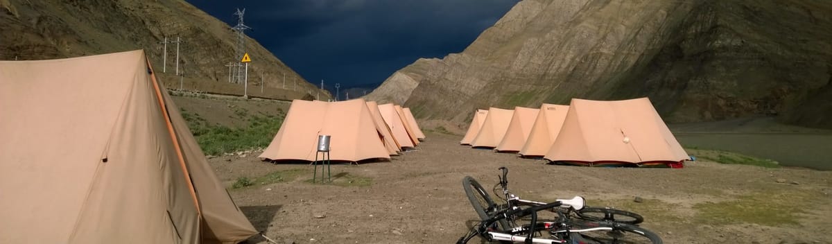
We camped beside a manmade lake, power & water for irrigation. I forgot to check the altitude but was told tonight's camp was about 4100m.
There were some Chinese workers living/working near the site. They saw me taking notes, on OneNote, with my phone so showed them the Nokia map. Showed them NZ then zoomed to the nearest village, current location, and they laughed but said map was right! I have found the off-line Windows Phone Nokia Here maps and info to be very good in some very remote places.

They were very interested in the bikes and suspect it may have been more than curiosity as there had some trouble at this site on a previous trip. Our bikes are always locked at night (in the mess tent if nothing better is available) but we were told to keep all our stuff inside the tent.
In the end there was no trouble and a bit of overnight rain meant would of had to do that anyway. I started dialling down my Diamox, altitude adjustment medication, from one tab a day to half and felt ok. I've had no headaches, just a dry throat and slight gaspy cough. Tashi called it ‘Tibet Cough’, a common thing at this altitude. Strangely it seems worse at rest than when riding.
Dinner dramatics
As we dined a spectacular storm passed over the distant mountains but fortunately missed us. The contrast between sunlit foreground slopes and threatening dark grey/black clouds was impressive. No filters used on the photo below.

Quote of the day:
"Only problem with this inflatable pillow I got in Lhasa is you nearly pass out from the effort of blowing it up!" - Me, to Andy, after nearly passing out.
Altitude:
Camp altitude ~4100m